Open Cabin
5955 West Paso Bonito Trail
Kathy and Gerry Davis
Parking: 5825 West Paso Bonito Trail (large white house)
Sunday, May 25, 2025
10:00am-1:00pm
Driving Directions
There are two ways to get to the Cabin, the Thumb Butte Rd route and Iron Springs-Skyline route. We strongly recommend taking the Thumb Butte route .
If you are stubborn and take Iron Springs-Skyline route, see attached map. Do NOT trust Google! Don’t follow directions that take you to Valley View Dr from Skyline Dr. The uphill portion of Paso Bonito from Valley View Dr is NOT NAVIGABLE BY CAR! ⚠️ 😱 ⚠️
Thumb Butte Rd Route (recommended!)
- Go west on Gurley St (main east-west street by the Courthouse).
- This becomes Thumb Butte Road. You will drive about 5 miles on a 2-lane paved road.
- When Thumb Butte Road ends at a T intersection, turn right toward N. Happy Valley Road (unpaved but good forest road marked Burton Rd).
- After .8 miles at another T intersection, turn left onto N. Happy Valley Road (pavement begins)
- In a quick 200 feet, turn left onto Paso Bonito Trail (unpaved).
- Continue up Paso Bonito about .4 miles
Parking
Parking will be at the neighbors house, a large white house on the left (5825 Paso Bonito). Park in the circular driveway (pull forward to make room for vehicles behind you), near the barn, or close to the road.
If parking is full text Kathy or Paul (see below) and they will direct you to alternative parking.
Final leg
Option #1: Walking
From there, there is a short invigorating walk. Continue west on Paso Bonito, past Ladera Trl, the "Davis Treehouse" driveway will be on your left. There is a bridge over a small ravine and a steep unpaved driveway to walk up.
Option #2: Shuttle
If you're unable to make the trek from the parking area, please text Kathy or Paul and you will be picked up, tout de suite!
- Kathy Davis 602-882-3106
- Paul West 602-332-8322
Maps
Thumb Butte Route
Thumb Butte Map Download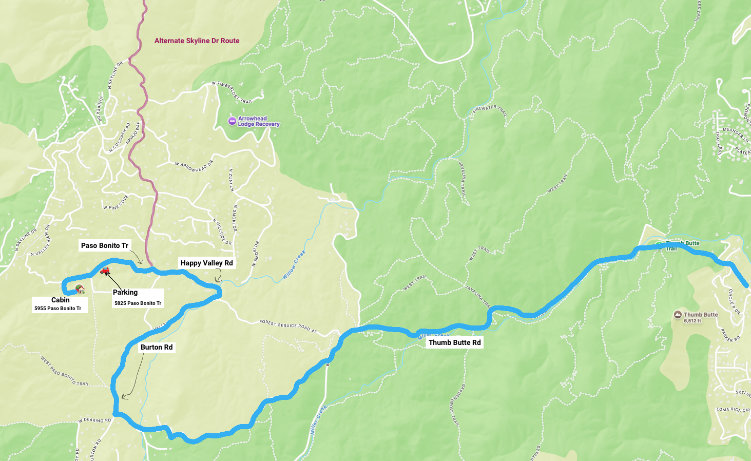
Springs-Skyline Route
Iron Springs-Skyline Map Download